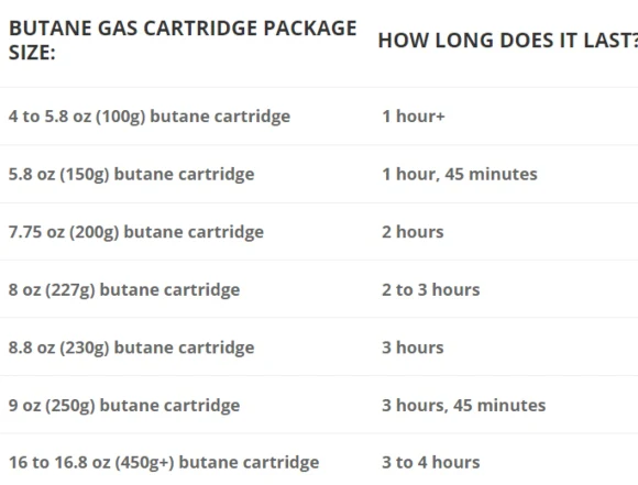
Killarney National Park Map
A definitive detailed map at 1:20,000 scale covering Killarney National Park and Mangerton Mountain. The map extends from the Gap of Dunloe to Glenflesk. Includes Killarney town, National Park, Purple & Mangerton Mountains. Produced to our 25Series standard, this general topographic map has a 5-metre contour interval for fine navigation. Signposted walking trails are depicted. Detailed topographic map with many placenames and heritage sites. Printed on good quality Progeo 90gsm map paper. The map sheet measures 1125mm x 820mm, covering 350 sq kilometres and is folded down to 125mm x 205mm.
Original: $25.85
-65%$25.85
$9.05Product Information
Product Information
Shipping & Returns
Shipping & Returns
Description
A definitive detailed map at 1:20,000 scale covering Killarney National Park and Mangerton Mountain. The map extends from the Gap of Dunloe to Glenflesk. Includes Killarney town, National Park, Purple & Mangerton Mountains. Produced to our 25Series standard, this general topographic map has a 5-metre contour interval for fine navigation. Signposted walking trails are depicted. Detailed topographic map with many placenames and heritage sites. Printed on good quality Progeo 90gsm map paper. The map sheet measures 1125mm x 820mm, covering 350 sq kilometres and is folded down to 125mm x 205mm.